
GeoMine Foundation Module for Threedify products
GeoMine Foundation, GeoMine is a fully integrated mining software suite for geological modeling, mine planning and design, and scheduling for both open pit and underground mines. The Foundation module provides a unified workspace and CAD tools that are common to all other modules in GeoMine and helps project data flow seamlessly among all modules. No more import and export between disjoint applications, each addressing a specific stage of the complex mine planning process.
Foundation Key Benefits
- Unified Workspace: All modules in GeoMine work coherently and seamlessly within the single integrated workspace, eliminating the need for incremental import/ export steps and thereby significantly increasing productivity.
- Easy to use: Fully event-driven non-blocking user interface helps improve efficiency
- Versatile: Includes a slew of advanced CAD tools.
Foundation Feature List
System Requirements:
CPU: Quad Core
RAM: 8gb
HARD DRIVE: 500gb SSD
VIDEO CARD: 1gb VRAM
CPU: 3rd Gen Ryzen 5/7 or Intel i7
RAM: 16gb
HARD DRIVE: 1tb SSD
VIDEO CARD: 2gb VRAM
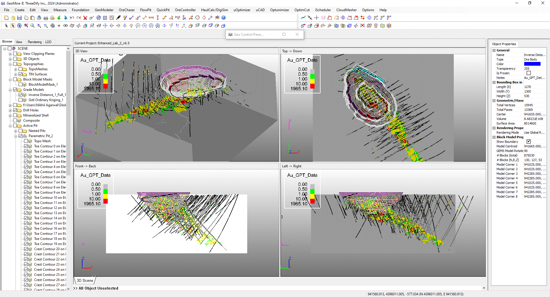
Defines block model universe orientation and dimensions manually or automatically from an existing block model CSV file; Defines the Mine Coordinate System (NEZ) for modeling.
Supports an astronomic block model universe with (2^40 x 2^40 x 2^40) blocks
Imports/Exports block model CSV files; Creates empty, full or partial block models from an existing block model with or w/o sub-blocking; Boolean operations on block models (intersection, union, subtraction and XOR); Automatic models clipping by topography; Creates attribute/grade shells from block models in real-time;
Creates swatch plots, PP and QQ plots, and histogram comparison plots for model validation; Creates grade-tonnage curves; Fills holes in Block Model; Modifies internal block model properties by user formulae; Shows model statistics; Searches individual blocks by XYZ or IJK; Exports block models and statistics to files. Classifies Block Models by surfaces; Computes portions above and portions below a specified surface.
Imports continuous and/or categorical attributes from drillhole files or 3rd party block models. Creates continuous or categorical attributes using GeoMine’s powerful Formula Editor; Assigns attributes to block models or composites; Partition active attributes into data intervals and color-code block models, drillholes and composites by these intervals.
Generic Object Attribute creation; object classification and coloring by generic attributes.
Creates wireframes from cross-sectional polylines; Creates 2.5D gridded or TIN surfaces and sets such a surface as the active topography; Maps textures to surfaces and real-time shells.
Creates and edits axis-aligned, non-axis aligned or scaled cross sections.; Switches between 3D and Section modes.
Outputs built-in block model statistics; Create grade-tonnage curves; Creates simplified block model reports and custom reports for block models, pit designs, cave designs, minable shapes and schedules with user-defined formulae.
Creates and edits user-defined formulas; Previews and debugs formulas; Copies and pastes full or partial formulas.
Defines color legend for active attribute; Defines drawing identification for plotting; Defines 2D and 3D display coordinate systems (for plotting).
Transforms existing CSV files by user-defined formulae; Reblock and normalize CSV files; Convert third-party sub-blocked CSV files to GeoMine *.tbm format.
Creates lines, polylines(2D or 3D), circles, ellipse, rectangles, cubes, boxes, spheres and ellipsoids; Copy, delete, move, rotate, or scale objects; Insert poly vertex; Moves poly or mesh vertex; Deletes poly or mesh vertex; Deletes mesh face; Extend/shorten objects; Flips face or object normal.
Creates extruded solids (from a polygon along a vector or path); Creates extruded solid from a mesh; Creates offset polygons; Creates polygonal profiles by slicing; Creates silhouette polygons from a mesh; Mesh simplification and optimization; Subdividess, smooths and simplifies polylines or polygon loop; Splits or joins polylines; Polyline fillet and chamber; Breaks multi-component objects into single component objects and vice versa.
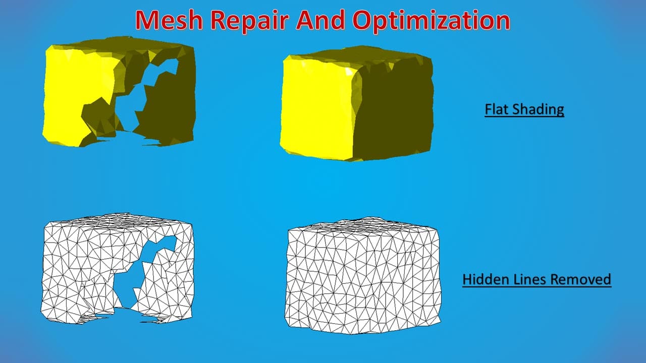
Boolean operations on polygons and 3D solids (intersect, union, subtraction and symmetric differences); Trim mesh by plane or polygon; Re-mesh by Triangulation or Marching Cubes; Mesh repairing by hole filling and solidification; Mesh offsetting.
Measures overdig and underdig volumes between two arbitrary topo surfaces; Computes overdig/underdig/intersection solids between two topo surfaces.
Creates static or associative linear dimensions (distance, axis aligned, point-to-plane), radial and angular dimensions; Creates 2D text, label and freehand objects; Measures line/plane azimuth and dip; Shows point/vertex coordinates.
Unlimited undo/redo history; Undo/redo last operation; Undo-to and redo-to a specific operation; Undo consecutive viewing operations; Inner command undo.
Orthographic and Perspective mode: True 3D perspective-correct zooming, pan, spin, ten preset views (including four isometric views), set view target, switch view to object, add/move/rotate/delete view clipping planes.
Range-select objects (within or outside a window); Area-select objects (within or outside a polygonal region); Select a single object; Un-select all objects; Hide or un-hide single or multiple objects.
Groups object into folders or groups with drag & drop and area-select interfaces.
Software and hardware rendering modes: Wireframe, flat shading, smooth shading, hidden line removal rendering modes; Backface cull, background color/image/texture, grid on/off, snap cursor to grid or vertex, show face normal on pick, show polyline vertex number Material colors: diffuse, specular, ambient, emissive, height, normals, shininess, opacity, vertex displacement, ambient occlusion; Transparency and lighting properties (up to 8 lights).
Starts new project, opens saved project.
Save, save as, save and backup projects.
Imports block model CSV files; Shapefiles and many other 3D generic formats, including the popular DWG, DXF, Datamine DM and point.
Supports over 40 GIS vector formats and over 70 GIS raster formats; Displays drillholes and property lines on Google or Bing maps and much more.
Exports DWG/DXF, Collada(.dae), GLTF/GLTB, Meshes(.ply, .stl), XGL, VRML 2.0, ASCII Block Models(.csv), Datamine Block Models(.dm), Point Clouds(.pcd, .ply), Polylines (.plx), Surpac STR, Face Azimuth/Dip file formats as well as AVI video format.
Automation Interfaces; Import/Export Plugin SDK.
Our mission is to empower our clients to turn data into insights, respond to project changes quickly, and improve efficiency, profitability, and sustainability.
Office Phone: +1-613-454-5327
Toll Free in North America: +1-855-760-4063